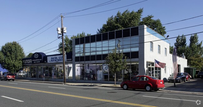
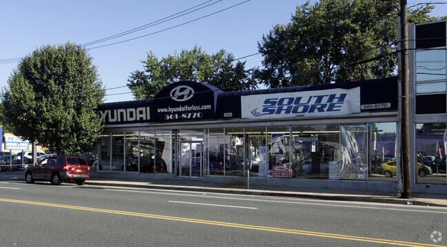
Property Record
599-621 W Merrick Rd, Valley Stream, NY 11580
NEARBY LISTINGS FOR SALE OR LEASE
Property Detail
599-621 W Merrick Rd
Nassau County-Suffolk County, NY
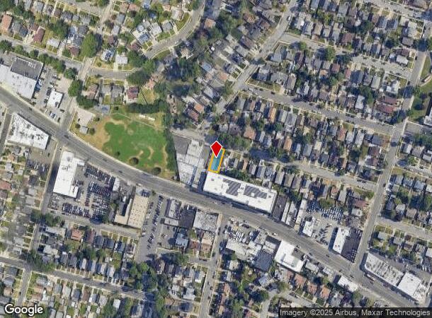
Map Of Property At Valley Stream
2035-37-473-00-0242-0
TOWN #1 SCH DIST 030
Shipyard
Nassau
X
New York
36059C0211G
242-2
0
0.82 AC
2025
Southern Nassau
410500
Long Island (New York)
120,720 SF
DEMOGRAPHICS near 599-621 W Merrick Rd
1 Mile
3 Mile
5 Mile
2024 Total Population
34,014
304,688
766,304
2029 Population
32,581
288,325
725,045
Pop Growth 2024-2029
(4.21%)
(5.37%)
(5.38%)
Average Age
41
42
41
2024 Total Households
10,199
95,107
239,067
HH Growth 2024-2029
(4.47%)
(5.66%)
(5.59%)
Median Household Inc
$110,076
$106,694
$96,778
Avg Household Size
3.20
3.10
3.10
2024 Avg HH Vehicles
2.00
2.00
2.00
Median Home Value
$589,738
$628,628
$661,003
Median Year Built
1952
1952
1951
Nearby Places
- Restaurants
- Banks
- Shops
- Fitness
- Groceries
PUBLIC TRANSPORTATION
COMMUTER RAIL
Valley Stream Station (Far Rockaway Branch - Long Island Rail Road, Long Beach Branch - Long Island Rail Road, West Hempstead Branch - Long Island Rail Road)
DRIVE
WALK
Distance
Valley Stream Station (Far Rockaway Branch - Long Island Rail Road, Long Beach Branch - Long Island Rail Road, West Hempstead Branch - Long Island Rail Road)
3 min
1.4 mi
Rosedale Station (Far Rockaway Branch - Long Island Rail Road)
DRIVE
WALK
Distance
Rosedale Station (Far Rockaway Branch - Long Island Rail Road)
4 min
1.8 mi
AIRPORT
John F Kennedy International
DRIVE
WALK
Distance
John F Kennedy International
13 min
6.9 mi
LaGuardia
DRIVE
WALK
Distance
LaGuardia
23 min
13.9 mi
Newark Liberty International
DRIVE
WALK
Distance
Newark Liberty International
50 min
33.6 mi
Freight Ports
NY - Red Hook Container Terminal
DRIVE
WALK
Distance
NY - Red Hook Container Terminal
34 min
18.3 mi
SALE & LEASE HISTORY
LISTING DATE
SALE/LEASE

Sep 25, 2016
For Lease
Sep 23, 2016
For Sale
Nearby Properties
Address
Land Use
TOTAL SIZE
Lot Size
Zoning
Address
Land Use
TOTAL SIZE
Lot Size
Zoning
124.60 AC
M1-1
Address
Land Use
TOTAL SIZE
Lot Size
Zoning
294.47 AC
PARK
Address
Land Use
TOTAL SIZE
Lot Size
Zoning
731,247 SF
56.09 AC
R3-2
Address
Land Use
TOTAL SIZE
Lot Size
Zoning
285,170 SF
12.63 AC
R3-1
Address
Land Use
TOTAL SIZE
Lot Size
Zoning
27.23 AC
PARK
Address
Land Use
TOTAL SIZE
Lot Size
Zoning
50,000 SF
52.45 AC
PARK
Address
Land Use
TOTAL SIZE
Lot Size
Zoning
129,378 SF
4.86 AC
R2A
Address
Land Use
TOTAL SIZE
Lot Size
Zoning
304,128 SF
3.70 AC
R6
Address
Land Use
TOTAL SIZE
Lot Size
Zoning
160,000 SF
4.02 AC
R3-2
Address
Land Use
TOTAL SIZE
Lot Size
Zoning
64,618 SF
8.04 AC
Address
Land Use
TOTAL SIZE
Lot Size
Zoning
165,600 SF
2.11 AC
R6
Address
Land Use
TOTAL SIZE
Lot Size
Zoning
93.35 AC
PARK
Address
Land Use
TOTAL SIZE
Lot Size
Zoning
178,870 SF
7.60 AC
M1-1
Address
Land Use
TOTAL SIZE
Lot Size
Zoning
122,080 SF
2.81 AC
R2
Address
Land Use
TOTAL SIZE
Lot Size
Zoning
5,296 SF
37.42 AC
PARK
Address
Land Use
TOTAL SIZE
Lot Size
Zoning
138,000 SF
7.06 AC
R3-2
Address
Land Use
TOTAL SIZE
Lot Size
Zoning
213,338 SF
2.91 AC
R3X
Address
Land Use
TOTAL SIZE
Lot Size
Zoning
252,665 SF
7.50 AC
R3-2
Address
Land Use
TOTAL SIZE
Lot Size
Zoning
97,190 SF
1.75 AC
R3X
Address
Land Use
TOTAL SIZE
Lot Size
Zoning
170,000 SF
4.02 AC
R3-2
Address
Land Use
TOTAL SIZE
Lot Size
Zoning
56,385 SF
7.81 AC
R6
Address
Land Use
TOTAL SIZE
Lot Size
Zoning
75,410 SF
5.12 AC
M1-1
Address
Land Use
TOTAL SIZE
Lot Size
Zoning
78,380 SF
0.85 AC
R3-2
Address
Land Use
TOTAL SIZE
Lot Size
Zoning
806 SF
84.15 AC
R2A
Address
Land Use
TOTAL SIZE
Lot Size
Zoning
260,000 SF
4.14 AC
R2
Address
Land Use
TOTAL SIZE
Lot Size
Zoning
96,071 SF
5.58 AC
M1-1
Address
Land Use
TOTAL SIZE
Lot Size
Zoning
149,804 SF
9.07 AC
M1-1
Address
Land Use
TOTAL SIZE
Lot Size
Zoning
141,782 SF
7.39 AC
M1-1
Address
Land Use
TOTAL SIZE
Lot Size
Zoning
122,740 SF
2.77 AC
R2
Address
Land Use
TOTAL SIZE
Lot Size
Zoning
14.58 AC
M1-1
The World's #1 Commercial Real Estate Marketplace
Connect with us
© 2025 CoStar Group
The information above has been obtained from sources believed reliable. While we do not doubt its accuracy we have not verified it and make no guarantee, warranty or representation about it. It is your responsibility to independently confirm its accuracy and completeness. Any projections, opinions, assumptions, or estimates used are for example only and do not represent the current or future performance of the property. The value of this transaction to you depends on tax and other factors which should be evaluated by your tax, financial, and legal advisors. You and your advisors should conduct a careful, independent investigation of the property to determine to your satisfaction the suitability of the property for your needs.